- Popular countries
- Popular regions
- Popular cities
- Popular airports
- Car Rental Italy
- Car Rental Spain
- Car Rental United States
- Car Rental Portugal
- Car Rental South Africa
- Car Rental France
- Car Rental Netherlands
- Car Rental Greece
- Car Rental Germany
- Car Rental United Kingdom
- Car Rental Belgium
- Car Rental Croatia
- Car Rental Switzerland
- Car Rental Austria
- Car Rental Denmark
- Car Rental Norway
- Car Rental Australia
- Car Rental Ireland
- Car Rental Cyprus
- Car Rental Canada
- Car Rental Florida
- Car Rental Sicily
- Car Rental California
- Car Rental England
- Car Rental Sardinia
- Car Rental Mallorca
- Car Rental Ibiza
- Car Rental Crete
- Car Rental Tenerife
- Car Rental Rhodes
- Car Rental Madeira
- Car Rental Corsica
- Car Rental Gran Canaria
- Car Rental Malta
- Car Rental Scotland
- Car Rental Azores
- Car Rental Fuerteventura
- Car Rental Lanzarote
- Car Rental Corfu
- Car Rental Zakynthos
- Car Rental Amsterdam
- Car Rental Milan
- Car Rental Miami
- Car Rental Lisbon
- Car Rental Malaga
- Car Rental Porto
- Car Rental Rome
- Car Rental Cape Town
- Car Rental Barcelona
- Car Rental Faro
- Car Rental Alicante
- Car Rental Nice
- Car Rental Bari
- Car Rental Naples
- Car Rental Johannesburg
- Car Rental Brussels
- Car Rental Bergamo
- Car Rental Orlando
- Car Rental Palma de Mallorca
- Car Rental Vienna
- Car Rental Amsterdam Schiphol Airport
- Car Rental Miami International Airport
- Car Rental Lisbon Airport
- Car Rental Malaga Airport
- Car Rental Porto Airport
- Car Rental Milan Malpensa Airport
- Car Rental Rome Fiumicino Airport
- Car Rental Faro Airport
- Car Rental Alicante Airport
- Car Rental Bari Palese Airport
- Car Rental Nice Airport
- Car Rental Barcelona Airport
- Car Rental Cape Town Airport - International Terminal
- Car Rental Bergamo Airport
- Car Rental Orlando International Airport
- Car Rental Mallorca Airport
- Car Rental Catania Airport
- Car Rental Johannesburg International Airport
- Car Rental Ibiza Airport
- Car Rental Athens Airport

Vancouver: The Best of Both Worlds
14 Must-See Stops on a Road Trip with a Rental Car
Vancouver is a wonderful city to spend at least a few days in. The Waterfront, the Gastown neighborhood, Stanley Park, and the suspension bridges in Capilano Park are Vancouver’s best-known attractions, but there’s much more to see and do. The city is one of Canada’s most popular tourist destinations because Vancouver combines the best of both worlds. In this bustling urban setting, you’re never far from wilderness, rugged mountain ranges, or secluded beaches. So after a few days in the city, it’s time to hop in your rental car and set off on an impressive road trip through British Columbia.
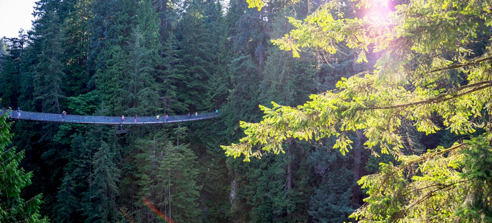
Many road trips starting in Vancouver follow the so-called Classic Loop, which runs all the way to Banff National Park in Alberta and back again. That’s quite a distance, and although you *could* cover it in two weeks, we don’t recommend it, because you won’t have time to enjoy all the sights along the way. Here we describe a shorter route, but we’ll provide suggestions for longer road trips at the end.
Bridal Veil Falls
To be honest, the first part of the route from Vancouver along Highway 1 (also known as the Trans-Canada Highway) isn’t all that spectacular, but the further east you drive, the more beautiful it gets. Take, for example, the turnoff to Bridal Falls. You’ll hear the waterfall the moment you step out of your rental car in the parking lot. It’s less than a fifteen-minute walk along a well-maintained trail, and along the way you’ll already see a few smaller waterfalls. The main waterfall is very wide, and the water plunges sixty meters down over smooth rock ledges. This gives it the appearance of a bridal veil, hence the name Bridal Veil Falls. You can take a different route back—the so-called Woodland Trail—through a lush forest with a thick carpet of moss, ferns, and shrubs.
Othello Tunnels
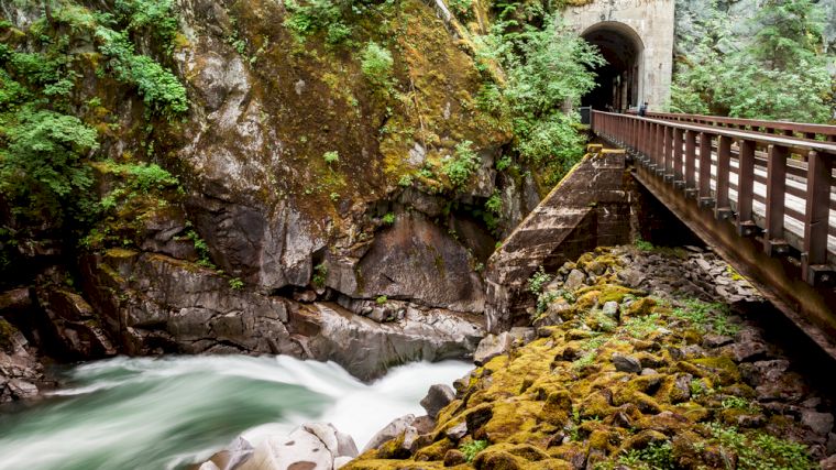
Just past Hope, the Othello Tunnels are definitely worth a visit. These tunnels through the mountains were dug by hand in 1914 to create a railroad line between the Kootenay region and the coast. The tunnels were closed after severe flooding in 2021 but were partially reopened in 2024 and fully reopened in 2025. It’s a popular attraction, so it’s best to park your rental car fairly early in the parking lot, which you can reach via Highway 5 (or from Hope via Othello Road). The route through the tunnels is flat, and along the way you’ll enjoy fantastic views of the deep, steep ravine of the wild Coquihalla River. You can take a different route back to the parking lot, but the Hope Nicola Valley Trail is much more challenging than the flat path through the tunnels!
Fraser River / Hell’s Gate
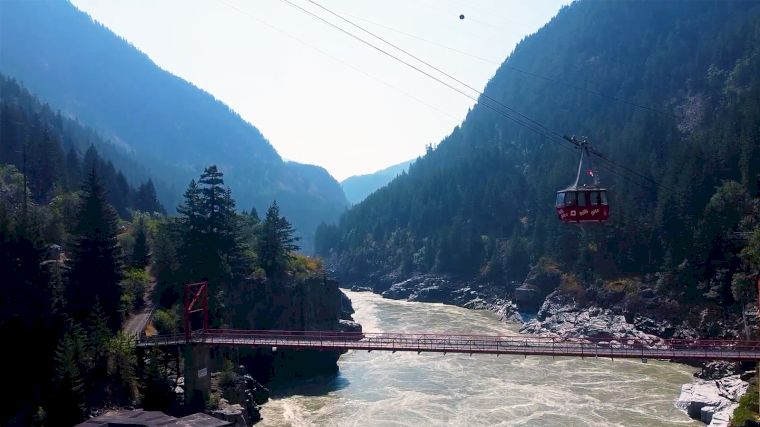
In the town of Hope, you’ll drive your rental car across a steel bridge over the Fraser River. After driving 40 kilometers north, you’ll cross the river again and can take a lunch break at the Old Alexandra Bridge, where a picnic area has been set up. This historic bridge dates back to the 1920s and is surrounded by a small park with an observation deck. The walk to the bridge takes ten minutes from the parking lot. Back in your rental car, the scenery becomes truly spectacular further on at Hell’s Gate—so named because the river narrows there into a roaring, churning whitewater current. This is the deepest and narrowest part of the Fraser River. There’s a gondola (Airtram) that takes you down: a very steep ride that descends over 150 meters along a 300-meter route—that’s a gradient of about 50%! From the suspension bridge over the river (with an open lattice floor beneath your feet), you can see salmon swimming upstream in October. In the summer, you can also go rafting here, but if you find the rapids too wild, there are plenty of other options further down the river.
Lytton
A little further north lies Lytton, at the point where the Thompson River flows into the Fraser River. You can see the confluence very clearly, as the water of the Thompson is clear, while the water of the Fraser has a brownish color due to the mud. Lytton was a very old settlement, which the Indigenous people called Camchin, meaning “meeting place.” In 2021, the village was almost completely destroyed by wildfires, but reconstruction began in 2024. There are also once again opportunities to go rafting on the Thompson River in the area.
Just north of Lytton, another river flows into the Fraser: the Stein River. The entire watershed of that river is a protected nature park named after the indigenous people: Nlaka’pamux Heritage Park. The elevation differences are significant: from 210 meters above sea level at the river’s mouth to the 2,968-meter-high Skihist Mountain. Most hiking trails involve challenging multi-day hikes, such as those leading to one of the four large lakes. From the eastern entrance, there are also a few shorter trails leading to picnic areas. You can reach the park by crossing the Fraser River north of Lytton on a free ferry and then driving your rental car five kilometers north.
Gold Country
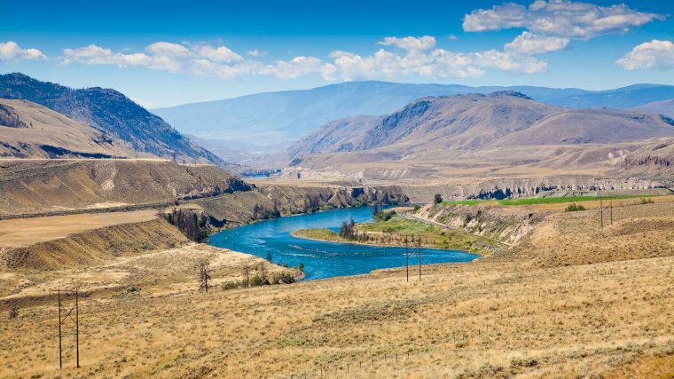
Lytton was once a stopover for gold prospectors. You’re now in the heart of the Gold Country, which takes its name from the gold rush that broke out here after gold was discovered in the Fraser River in the mid-19th century. Drive your rental car northeast along the Thompson River and you’ll see the landscape change. Around Cache Creek, the landscape is distinctly desert-like, with cacti, sage, and tumbleweed. Wherever you see clusters of trees, there’s water; there are several small lakes in the area where you can enjoy a swim.
The historic Hat Creek Ranch, just north of Cache Creek, is a fun (and educational) place to visit. The original 19th-century stagecoach stop is well-preserved, both inside and out. There’s also extensive coverage of the way of life of the indigenous people and how they lived off the land for thousands of years before the settlers arrived. You’ll see shelters, hunting and fishing gear, how food was stored, and even an indigenous dwelling, a round kekuli. There are also exhibits of traditional art, and you can take rides on the stagecoach. You can even stay overnight there.
Lillooet
Hat Creek Ranch is located at the T-junction of Highways 97 and 99. That’s convenient, because the latter road leads to the next destination, Lillooet. It’s a stunning route through Marble Canyon and right past two lakes with the fitting names Turquoise Lake and Crown Lake. Just before Lillooet, there’s a lookout point along the road where you can see, among other things, the old bridge over the river. It’s a great spot for a lunch break. To get there, take the turnoff to Fraser Cove a little further down the road. In this area of rugged, rocky mountains, Lillooet’s slogan, “guaranteed rugged, ” is once again fitting. It’s one of the oldest towns in British Columbia, and it certainly shows. All over Lillooet, you’ll see signs describing historic routes, collectively known as the Golden Miles of History.
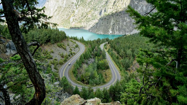
Want to visit (or revisit) a beautiful lookout point? Then drive your rental car to Seton Lake Lookout, about 7 kilometers west of Lillooet, just past a sharp hairpin turn. From the parking lot, you can walk a little further up, but you’ll need to cross the road to do so. From there, you’ll have a fantastic view of the lake, Mount McLean, and the U-turn in the road. On the eastern shore of Seton Lake is a small beach where you can swim, kayak, and picnic—or simply enjoy the lake and the surrounding mountains.
For an unforgettable experience, set aside your rental car for a day and take a trip along the railroad tracks that run along the north shore of Seton Lake. Trains no longer run on this line, but there is a bus that has been modified to run on the tracks—though its name is a bit confusing: Tsalalh Seaton Train. You can make a round trip in a single day.
Duffey Lake / Pemberton
As you continue driving along Highway 99, the scenery becomes more and more beautiful. Just a few kilometers further on, there’s another stunning lake right beside the road: Duffey Lake. The reflection of snow-capped Mount Matier and Joffre Peak in the lake’s mirror-smooth water is particularly magnificent. These mountains are located in the Joffre Lakes Provincial Park. Unfortunately, this nature park—with its three glacial lakes—has very limited access. You can reserve a day pass online starting at 7 a.m. two days in advance, but many people complain that they sell out within seconds of 7 a.m. Fortunately, there are plenty of other opportunities to enjoy the outdoors, especially in the Pemberton area. The Mount Currie Trail is a challenging hike, but you’ll be rewarded with panoramic views. The flat One Mile Lake Trail is an easier option. It’s not just hikers who’ll find something to enjoy; around Pemberton, you can also go mountain biking, take a horseback ride, participate in water sports, or go paragliding. The history of the town and the region comes to life at the Pemberton Open-Air Museum, where you can see old houses, shops, and their interiors.
Sea-to-Sky Highway
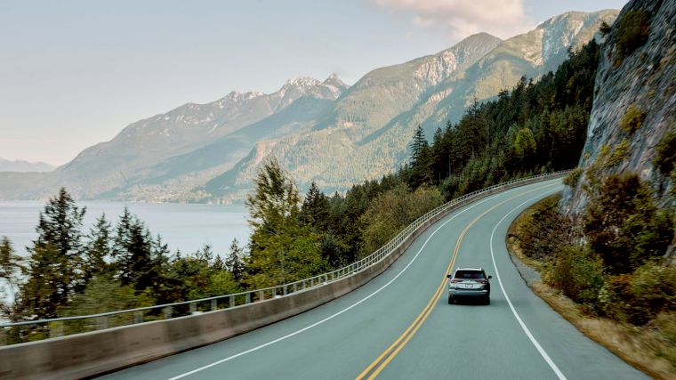
Pemberton is located at the end of the iconic Sea-to-Sky Highway, but since you’re in Pemberton with your rental car, in your case it’s the Sky-to-Sea Highway. It’s no wonder this road is considered one of the most beautiful in Canada. On the way back to Vancouver, you’ll be immersed in breathtaking scenery, with a new, incredibly beautiful view around every bend. But that’s not the only thing that makes this road so appealing. If you drive straight through, you can cover the route in two hours, but with all the wonderful stops along the way, it can easily take two days or more. Along the route, you can visit cultural and historical sites, go hiking or biking, or enjoy other outdoor activities such as swimming, scuba diving, or mountain climbing. It’s a stunning drive and, for many people, the highlight of their trip through British Columbia. So be sure to allow plenty of time and keep your camera ready!
The best time to drive the Sea-to-Sky Highway is from June through September. By then, the snow has melted, and the hiking and biking trails are accessible. Keep in mind, however, that during the peak months of July and August, this road can get busy, especially on weekends. Don’t let speeding drivers rush you, but do give them room to pass whenever possible.
Whistler
Just south of Pemberton, there’s a turnoff to the parking lot at Nairn Falls Provincial Park. After about a twenty-minute walk along a fast-flowing river, you’ll reach an impressive waterfall consisting of several sections with pools in between and intriguing rock formations. Near Whistler are the Alexander Falls. You can easily reach the waterfall by rental car, as the viewing platform is right next to the parking lot. Brandywine Falls, south of Whistler, is also very impressive, but you’ll need to take a short walk to see it. East of that waterfall, you can jump 50 meters off the Bungee Bridge over the Cheamaus River.
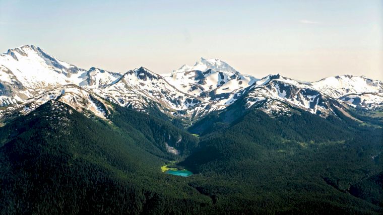
Whistler is known as a winter sports destination, but it’s also a fantastic area to visit in the summer. If you rent bikes, you can take a beautiful ride along the Valley Trail, passing all five lakes near the town: Lost Lake, Green Lake, Alta Lake, Alpha Lake, and Nita Lake. Rainbow Park is a great place to swim, while Lakeside Park offers sailing, kayaking, and kitesurfing. There are gondola rides to Whistler Mountain and Blackcomb Peak, with another gondola (Peak 2 Peak) connecting the two peaks that offers breathtaking views of mountain peaks, lakes, glaciers, and forests. From Whistler Mountain, there’s a footbridge— the Cloudraker Skybridge—leading to the start of the High Note Trail. Not for those afraid of heights, as the bridge sways quite a bit and you can see the glacier and cliffs below through the latticework. This is just one example, as there are hiking trails totaling over fifty kilometers. There are also severalziplines in Whistler, including one that’s a full two kilometers long.
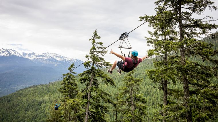
One downside of Whistler: accommodations there can be shockingly expensive. You can drive 45 minutes south in your rental car to make Squamish your base.
Squamish
If you’re heading to Squamish, don’t forget to stop at Tantalus Lookout. There, you’ll enjoy an unbeatable view of the rugged, snow-capped Tantalus Range, the favorite mountain range among climbers in British Columbia. Tip: if you’re driving this route in the opposite direction in your rental car, there’s a side road leading to a slightly higher vantage point.
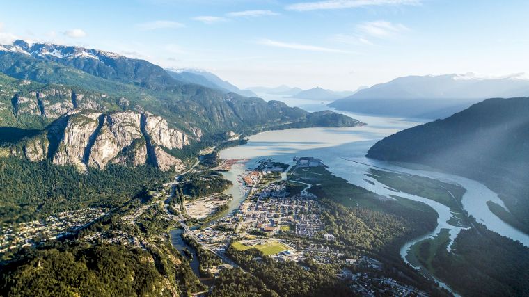
Squamish is a paradise for rock climbers, not only because of the mountains in the Tantalus Range, but also because of the enormous variety of routes along one of the world’s largest freestanding granite monoliths, Stawamus Chief Mountain. There are routes for both beginners and highly experienced climbers. Not really in the mood to climb yourself, but still want to enjoy a high vantage point? Then take the Sea-to-Sky Gondola. It’s an unforgettable experience with views of Howe Sound, The Chief, and Shannon Falls. Of course, you’ll want to see that waterfall up close, too. That’s not too hard—just drive 400 meters from the parking lot at the gondola station in your rental car and take a short walk to the waterfall.
Garibaldi Park
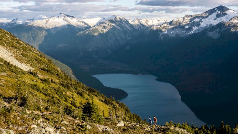
Garibaldi Park is enormous and stretches east of the Sea-to-Sky Highway. The lake of the same name (and the park’s most popular section) is located just north of Squamish. Here, too, you’ll need a day pass during the summer (from mid-June to early September), which you can reserve two days in advance. A day pass is also required on weekends in September and October. Each pass is valid per vehicle (with a maximum of 12 passengers), not per visitor. Availability depends on the number of parking spaces at the trailheads for the Diamond Head Trail and Rubble Creek Trail. The latter has the largest parking lot, with space for 200 cars. The trail runs along Rubble Creek to the picturesque area around Garibaldi Lake. From there, you’ll have views of glaciers and mountain peaks such as Black Tusk, Panorama Ridge, and The Table, which somewhat resembles an upside-down teacup. Mountain biking is only permitted from the start of the Diamond Head Trail. In winter, the vast park is a dream destination for skiers and cross-country skiers.
Britannia Mine Museum
As you drive back toward Vancouver, you’ll enjoy stunning views of Howe Sound on your right and mountains on your left. In Britannia Beach, you’ll notice a building constructed against the hillside. That’s the famous Mill 3 of a former copper mine. Pull your rental car over there for a moment to visit the Britannia Mine Museum and experience what life was like in a bustling mining town. You’ll see how copper ore was mined and processed using enormous machines. To complete the experience, be sure to hop aboard the little train, which takes you underground through a former transport tunnel. It’s quite cool in there (about 12 degrees Celsius), so be sure to wear a sweater or jacket. The work in the mine really comes to life with the spectacular multimedia show BOOM!
Tunnel Bluffs
A little further on, the village of Lions Bay nestles against a steep mountainside. Here, too, you can enjoy beautiful hikes. Challenging trails lead high into the mountains to the summits of iconic peaks like the Lions—after which the village is named—or the Tunnel Bluffs, offering incredible views. The first two kilometers of the latter trail are quite steep, but after that, the terrain becomes relatively flat. A rope is strung along the log bridges over the creeks, which you can hold onto.
After Lions Bay, you’re almost back in Vancouver. From Horseshoe Bay, north of the city, ferries depart for destinations including Bowen Island and the city of Nanaimo on the much larger Vancouver Island.
Vancouver Island
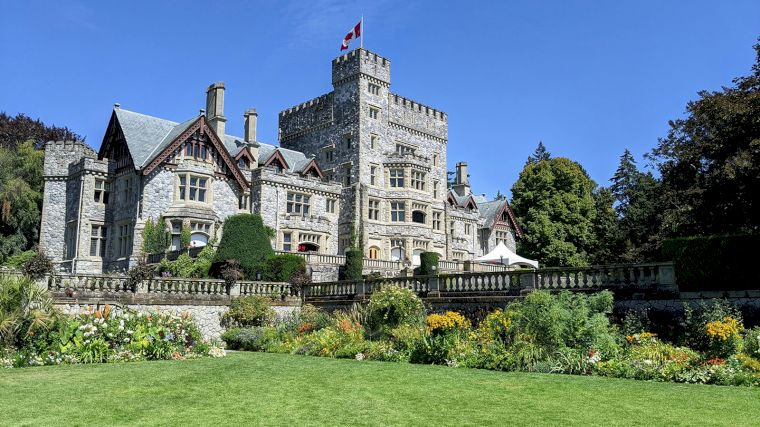
Many people take a day trip to Victoria on Vancouver Island, but it’s also a great starting point for a longer road trip. The island is so large and there’s so much to see, do, and experience that you can easily spend two weeks or more there. But first, Victoria, the capital of British Columbia. To get there by rental car, drive from Tsawwassen, south of Vancouver, and take the ferry to Swartz Bay, north of Victoria. The city boasts a wealth of historic buildings, including the Parliament Buildings and the Empress Hotel, colorful gardens—such as Butchart Gardens—and a lively harbor with the Fisherman’s Wharf entertainment district. The rich British history is palpable everywhere, except in Chinatown, the second-oldest Chinese neighborhood in North America, after San Francisco’s. The Royal British Columbia Museum is a must-see; it’s considered the best museum in all of Canada.
Drive your rental car from Victoria along Highway 1 to Malahat Summit Viewpoint, right next to the highway. On a clear day, you can look out across Saanich Inlet toward the mountains in the distance. It’s a great place to stop, breathe in the fresh air, and enjoy the island’s natural beauty. A little further on is the turnoff to the Malahat Skywalk, where you walk up a spiral wooden path and slide down a slide (though you can also walk down).
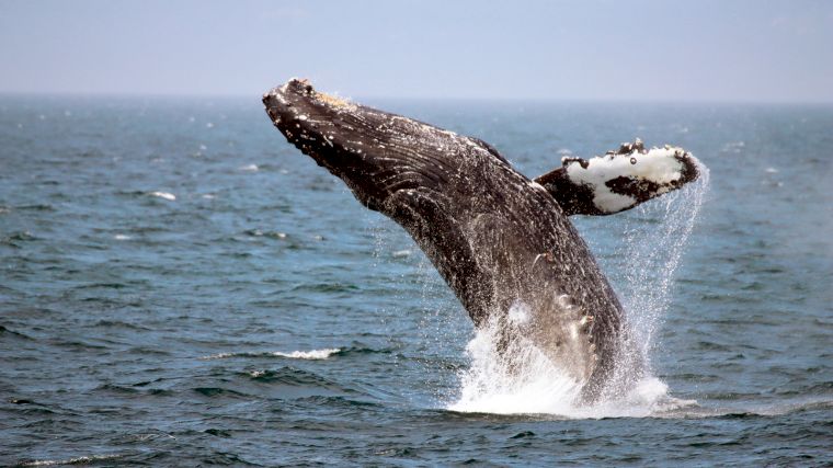
Vancouver Island is a fantastic destination for spotting orcas, humpback whales, and other whales, especially near Tofino and Ucluelet on the Pacific Rim. This west coast of Vancouver Island is known for its rugged beauty. The towns are surrounded by the Pacific Rim National Park Reserve, which provides a stunning backdrop for whale-watching tours. The best time to spot these large marine mammals is between May and September.
There are too many things to do on Vancouver Island to list them all. There are beautiful hiking and biking trails through dense forests; you can go kayaking, sailing, surfing, paddleboarding, diving, bear-watching, or explore caves and waterfalls. And don’t forget that you can also just relax on one of the sandy beaches. Some of those beaches, especially in the northern half, are practically deserted. The festivals you can attend at Parkville Beach in the summer are much busier. Have we forgotten anything else you can do on Vancouver Island? Undoubtedly. Discover the island for yourself by renting a car and seeking out the most beautiful spots.
By the way, did you know that you can also easily get to Vancouver Island from the United States? There are regular ferry services from Seattle to Victoria. Most American car rental companies don’t make a fuss if you cross the border with a rental car, but to be on the safe side, you should check with the rental company when you pick up the car.
Winter Tires for Rental Cars in British Columbia
On most of the highways mentioned above, winter tires are required from October 1 through March 31. For some other routes, the requirement extends through April 30. This is always clearly indicated on roadside signs. Winter tires are by no means always included when you rent a car in Vancouver, so be sure to check this carefully when booking your rental car. If you plan to drive on local roads in the winter, snow chains may also come in handy.
One-Way Vancouver–Calgary
We mentioned it briefly at the beginning: the Classic Loop; on Google Maps, you’ll find the route for this fantastic round trip starting from Vancouver. Just make sure you have enough time for it, because there’s so much to see and do along the way. Alternatively, you can drive half of the Classic Loop. Choose either the northern or southern route and book a one-way car rental from Vancouver to Calgary in the province of Alberta—or vice versa. It’s not difficult to arrange at all. Just enter your pickup and drop-off locations on our search form, and we’ll show you the rental cars available for that route. And you know what makes it even better? The route between Calgary and Vancouver is so popular that many car rental companies don’t even charge a one-way fee for it!
Why Rent a Car in Vancouver?
There’s no better way to discover Vancouver’s incredibly beautiful surroundings than by renting a car. Public transportation is good in this part of Canada, but a rental car is essential for reaching the most scenic spots. Plus, you’ll have complete freedom to decide where you drive, when you drive, and where you’re headed. We hope we’ve convinced you to explore Vancouver and British Columbia. Don’t wait any longer—reserve a rental car in Vancouver and hit the road!

Where would you like to rent a car?
- 24000+ pick-up locations
- Free cancellation
- Independent comparator

Useful tips for a well-prepared trip
Which insurance should I choose, and what's the deal with the deposit? Read our articles with useful information and tips to ensure you choose the right rental car for you.


