- Popular countries
- Popular regions
- Popular cities
- Popular airports
- Car Rental Italy
- Car Rental Spain
- Car Rental United States
- Car Rental Portugal
- Car Rental South Africa
- Car Rental France
- Car Rental Netherlands
- Car Rental Greece
- Car Rental Germany
- Car Rental United Kingdom
- Car Rental Belgium
- Car Rental Croatia
- Car Rental Switzerland
- Car Rental Austria
- Car Rental Denmark
- Car Rental Norway
- Car Rental Australia
- Car Rental Ireland
- Car Rental Cyprus
- Car Rental Canada
- Car Rental Florida
- Car Rental Sicily
- Car Rental California
- Car Rental England
- Car Rental Sardinia
- Car Rental Mallorca
- Car Rental Ibiza
- Car Rental Crete
- Car Rental Tenerife
- Car Rental Rhodes
- Car Rental Madeira
- Car Rental Corsica
- Car Rental Gran Canaria
- Car Rental Malta
- Car Rental Scotland
- Car Rental Azores
- Car Rental Fuerteventura
- Car Rental Lanzarote
- Car Rental Corfu
- Car Rental Zakynthos
- Car Rental Amsterdam
- Car Rental Milan
- Car Rental Miami
- Car Rental Lisbon
- Car Rental Malaga
- Car Rental Porto
- Car Rental Rome
- Car Rental Cape Town
- Car Rental Barcelona
- Car Rental Faro
- Car Rental Alicante
- Car Rental Nice
- Car Rental Bari
- Car Rental Naples
- Car Rental Johannesburg
- Car Rental Brussels
- Car Rental Bergamo
- Car Rental Orlando
- Car Rental Palma de Mallorca
- Car Rental Vienna
- Car Rental Amsterdam Schiphol Airport
- Car Rental Miami International Airport
- Car Rental Lisbon Airport
- Car Rental Malaga Airport
- Car Rental Porto Airport
- Car Rental Milan Malpensa Airport
- Car Rental Rome Fiumicino Airport
- Car Rental Faro Airport
- Car Rental Alicante Airport
- Car Rental Bari Palese Airport
- Car Rental Nice Airport
- Car Rental Barcelona Airport
- Car Rental Cape Town Airport - International Terminal
- Car Rental Bergamo Airport
- Car Rental Orlando International Airport
- Car Rental Mallorca Airport
- Car Rental Catania Airport
- Car Rental Johannesburg International Airport
- Car Rental Ibiza Airport
- Car Rental Athens Airport

Discover that Fuerteventura is more than just sandy beaches
Rent a car to see the most beautiful sights
Fuerteventura is the second-largest of the Canary Islands (after Tenerife) and very long and narrow. The distance between the northern and southern tips along the main roads is more than 100 kilometers. You can easily drive around the island in a day, but you’ll miss a lot. There are so many spots that invite you to stop and enjoy the volcanic landscape, charming little villages, or the view of the Atlantic Ocean.
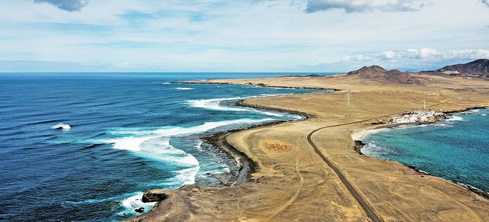
If you want to discover the best spots on the island and make the most of your vacation, we recommend renting a car. It’s by far the best way to get around. Plus, you won’t be limited to staying at just one resort; you can easily drive to various long, wide sandy beaches and attractions on Fuerteventura. Most people rent a car as soon as they arrive at Fuerteventura Airport, near the capital, Puerto del Rosario, but you can also rent a car elsewhere on the island, such as in Corralejo (in the north) and Costa Calma (in the south).
Below, we describe some of the most beautiful attractions and sights on Fuerteventura. Of course, we can’t possibly cover everything on this fascinating island, so please consider these suggestions merely as a guide. Rent a car and discover even more beautiful spots on Fuerteventura for yourself!
Dunas de Corralejo / Montaña Roja
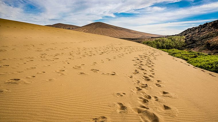
As you drive north along the FV-104 coastal road, you’ll be amazed by the breathtaking natural beauty of the Corralejo sand dunes. Some of these impressive dunes reach heights of up to fifty meters and provide a striking contrast to the azure-blue Atlantic Ocean. It’s often claimed that the sand here “blew in from the Sahara,” but that’s not true. They were formed—just like beaches—by the decomposition of shellfish and other marine organisms.
With kilometers of pristine white-sand beaches, crystal-clear water, and a backdrop of dark brown or black volcanic landscape, it’s no wonder this is one of the most visited areas on Fuerteventura. If you take a walk through the dunes, make sure you keep a good sense of direction and know where your rental car is parked. Because sometimes the path is no longer visible.
The northern part of the coastline is known as Grandes Playas (big beaches) and is an absolute paradise for water sports enthusiasts. If you go swimming there, be aware of the high waves and sometimes strong currents. Further south, there are smaller beaches, such as Playa Alzada, where the main road runs right alongside them.
For the best view, climb Montaña Roja (Red Mountain). This 314-meter-high volcano on the southern edge of the dune area is a great spot for photography on a clear day: from the top, you’ll have a panoramic view of the dunes, the sea, the islet of Lobos, and the neighboring island of Lanzarote. The slope isn’t very steep, but you’ll be walking on loose gravel, so it’s best to wear good hiking shoes.
Corralejo / Lobos
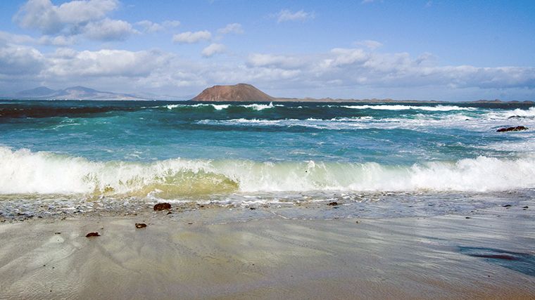
One of the best day trips you can take during your vacation on Fuerteventura is a trip to the uninhabited island of Lobos. Park your rental car at the port of Corralejo and board the ferry or water taxi there. Some ferry services even extend their route a bit to include an extra stop for snorkeling.
Lobos is a small island, but it boasts a variety of landscapes: beaches, desert, wetlands, a volcanic crater, and a lagoon. Most fascinating are the lava mounds, called hornitos. They form when lava comes into contact with water, causing explosions. There’s a hiking trail around the island that starts at the dock and covers a total of about eight kilometers. If you don’t want to walk the entire route, you can choose a section. The westernmost route runs along the semicircular volcanic crater, which you can climb for a beautiful view. The eastern trail passes through the Las Lagunitas wetlands, a lush green landscape you wouldn’t expect to find on this otherwise barren volcanic island.
After the hike, you can cool off at one of the beaches. The most popular is Playa de la Concha, but if you walk a little further, you’ll reach the quieter Playa de la Caleta. Keep in mind that there are hardly any amenities on Lobos, so be sure to bring plenty of water and provisions. There is a small café at the boat landing, but it can get very crowded. Furthermore, access to the island is limited to 400 people per day: 200 in the morning (from 10:00 a.m. to 2:00 p.m.) and 200 in the afternoon (from 2:00 p.m. to 6:00 p.m.). If you want to hike on the island, it’s best to choose the morning hours when applying for your (free) permit.
Calderón Hondo
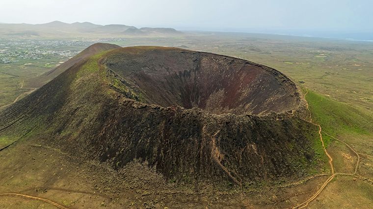
The Calderón Hondo is one of the best-preserved volcanic craters on Fuerteventura and is located east of the road from Lajares to Majanicho. You can park your rental car just outside Lajares at the information sign about the hiking trails to the volcanoes. Yes, plural—because the Hondo isn’t alone; it’s part of a chain of volcanoes. As you walk along the trail (Camino Calderas), you’ll reach a fork after about five hundred meters. The left path leads to the western slope of the Hondo, while the right path leads to the southern slope, which is less steep.
During the climb, you’ll be treated to increasingly spectacular views of the amazing row of volcanoes and the plain on which they stand. Just below the summit, the climb gets a bit steeper, but once you’re there, you’ll be convinced that your efforts were well worth it. At an elevation of 278 meters, you’ll have a panoramic view of northern Fuerteventura, the islet of Lobos, and Lanzarote in the distance. The light is fantastic at sunset, but don’t start your descent too late—you don’t want to be walking here in pitch darkness. The crater itself is also fascinating: seventy meters deep, with traces of yellow sulfur near the ground. If the wind isn’t too strong, you can walk all the way around the crater.
El Cotillo
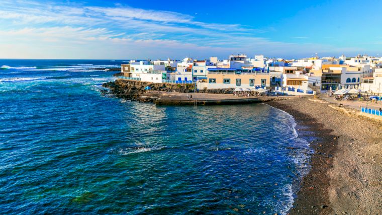
Most of the fishing villages on Fuerteventura have now become tourist hotspots. El Cotillo also attracts visitors because of the beautiful sandy beaches nearby, yet this village has a completely different atmosphere than the more popular tourist destinations. The town center is undeniably charming, especially around the small beach with black pebbles. This isn’t a place for swimming, but rather for enjoying the view—for example, from the terrace of one of the surrounding restaurants. At sunset, this spot is bathed in a truly special light.
You can also drive your rental car to the lighthouse, just north of El Cotillo, for a beautiful sunset. Around that 33-meter-high lighthouse, you’ll see various types of rocks. At low tide, water pools between the rocks, and you can wade there with your children. Nearby is the gently sloping beach Playa de Los Charcos. The only structure you’ll see is the lighthouse.
Barranco de los Encantados
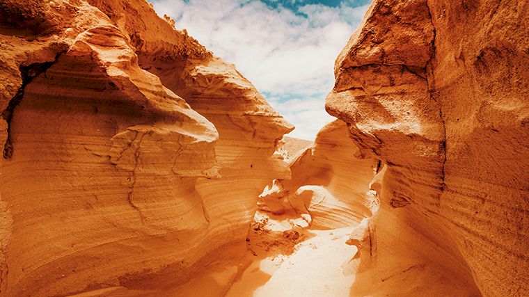
Fuerteventura has several ravines, known as "barrancos" in Spanish. They are mostly dry and offer unique spots to explore and photograph. The most remarkable ravine is Barranco de los Encantados (also known as Barranco de los Enamorados) in the north of the island. At certain times of the year, fog banks form, and according to the island’s original inhabitants, these were the spirits of their ancestors—hence the name “Gorge of the Enchanted.” The nickname “Gorge of the Lovers” comes from the fact that young couples from the area used to come here for a romantic evening. This gorge offers a surreal landscape of petrified dunes that have been shaped over thousands of years by water and wind.
The closest way to get there by rental car is to take the FV-10 north from La Oliva or south from Lajares. Just past the “km26” sign (from Lajares, almost a kilometer past the “km27” sign), there’s a turnoff onto a dirt road. Park at the beginning of the dirt road and walk about three kilometers west. We advise against driving your rental car on unpaved roads, as car rental companies do not permit it.
Ecomuseum de la Alcogida
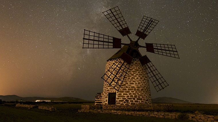
If you want to learn more about traditional rural life and crafts on Fuerteventura, the Ecomuseo de la Alcogida, near the village of Tefía, is highly recommended. It’s a reconstructed village with seven houses, ranging from the home of a wealthy islander to a simple farmhouse. This variety of traditional architectural styles takes you back in time. The best way to explore the museum is with a guided tour, during which you’ll learn what various objects were used for and how they were used. Guided tours start at 10:30 a.m. and 12:30 p.m.
While you’re here, you might as well take a short detour to see a traditional windmill, just west of the museum.
Museo del Queso Majorero
In a beautifully restored country house, just north of Antigua, you’ll find a museum dedicated to the island’s cheese: Queso Majorero. The nice thing is that this museum is about more than just cheese. Your visit begins in a beautifully restored windmill—one of many found on windy Fuerteventura. The volcanic origins of the Canary Islands are also explained through videos about geological events. The next room is dedicated to the island’s flora and fauna. This area is very educational for children, featuring interactive screens that display animal footprints, among other things. One of the animals that has managed to survive on Fuerteventura is the Majorera goat, which is renowned for the quality of its milk. And then you naturally move on to the process of making the famous cheese. You can, of course, taste for yourself how the flavor differs depending on the aging process!
Betancuria
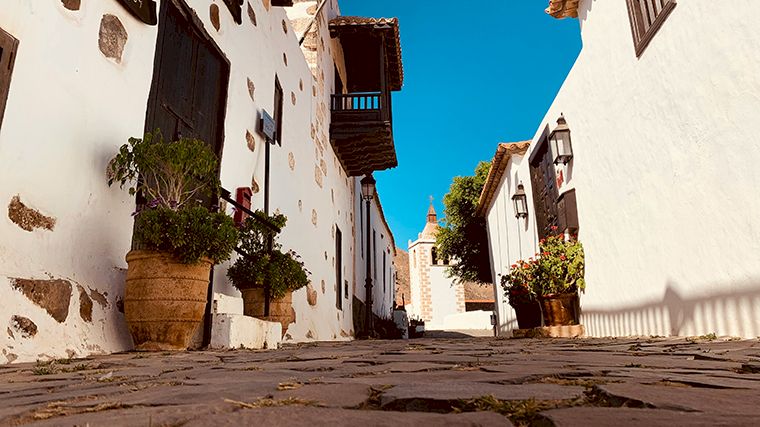
Located in the center of the island is the former capital, Betancuria, the oldest town on Fuerteventura. This charming, picturesque colonial town offers a glimpse into the past, before the rise of tourism. Betancuria was founded in 1404 by the Norman conqueror Jean de Béthencourt. The most impressive site in town is the Iglesia de Santa María, the first church built on the island. The church was destroyed by a pirate in 1593 and wasn’t rebuilt until a century later. The Museo Arqueológico has recently been expanded and features an impressive exhibition of pre-Hispanic pottery and other archaeological finds. There, you’ll also learn about the podomorfos—depictions of feet (sometimes very schematic)—found on sites such as the sacred mountain of Tindaya, all of which point toward Mount El Teide on Tenerife.
Road trip along the FV-30 with scenic overlooks
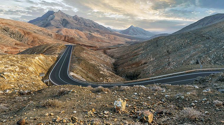
Betancuria is located along the FV-30 main road, which is an attraction in itself if you enjoy winding roads. Here, we describe the route from Casillas del Ángel in the north to Pájara in the south. Shortly after the T-junction with the FV-416 (toward Antigua), you’ll reach the first lookout point, Morro Velosa. To get there, you’ll need to take a small side road up to the summit at an elevation of 669 meters. Unfortunately, the café and the museum dedicated to the geology and unique flora and fauna of Fuerteventura have been neglected for years, but there are reportedly plans for renovation. The view is breathtaking.
Back on the main road, another viewpoint follows shortly afterward—you can’t miss it, as there are two enormous statues there. Two indigenous kings, Guise and Ayose, are immortalized here in larger-than-life bronze statues. They were, respectively, the kings of the north (Maxorata) and the south (Jandía) when Jean de Béthencourt conquered the entire island in the fifteenth century.
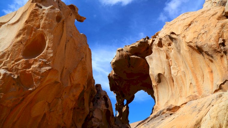
A little further on, you’ll reach the village of Vega de Rio Palma. If you want to stretch your legs, take the turnoff to the village for a walk through the Barranco de las Peñitas gorge. The gorge is still fairly manageable (with good hiking shoes), but there’s no clear trail to the remarkable Arco de las Peñitas rock arch. The climb is steep, and the rocks can be slippery. The best time to hike here is either early in the morning or late in the afternoon.
You might have found the hairpin turns on the FV-30 manageable so far, but from this point on, things really get interesting. The road is quite narrow in some places and has a few blind hairpin turns with steep drops. Still, buses drive here too, so it’s quite manageable as long as you keep your eyes on the road and drive slowly. Fortunately, there are plenty of places to park your rental car, so the driver can also enjoy the magnificent scenery. For example, at the Rosco de las Peñas and Barranco del Aceituno lookouts.
In the heart of Pájara stands the 17th-century church of Nuestra Señora de Regla. Above the main entrance, you’ll see depictions of sunbeams, snakes, panthers, and birds. Some experts believe these show Aztec influences.
Ajuy Caves
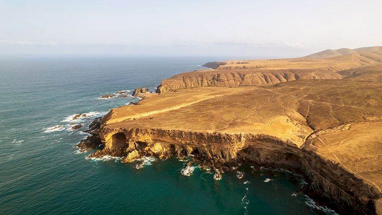
The small coastal village of Ajuy (ten kilometers northwest of Pájara) is best known for its intriguing caves. From the north end of the black-sand beach, an easy trail leads uphill, offering a beautiful view of the sea caves. At the start of the trail, there are information signs explaining the geology. Be sure to read them before you begin your walk—that way, you’ll understand what you’re looking at. At the end of the trail, you can descend a staircase to massive sea caves featuring stunning black rocks.
Playa de la Pared
Just south of Pájara, you’ll reach La Pared, on the wild, rugged, and windy western side of the narrow isthmus connecting the north and south of Fuerteventura. The tourist resort of Costa Calma is only five kilometers away from La Pared as the crow flies, but the contrast between the two places couldn’t be greater. La Pared is set in a dramatic landscape of jagged volcanic mountains and dark blue, foaming water. It’s a great place to learn to surf, but the rough waters with strong currents make it unsuitable for swimming. Incidentally, the village is named after the wall (Spanish: pared) that once separated the two kingdoms of Maxorata and Jandía.
Playa de Cofete / Pico de la Zarza
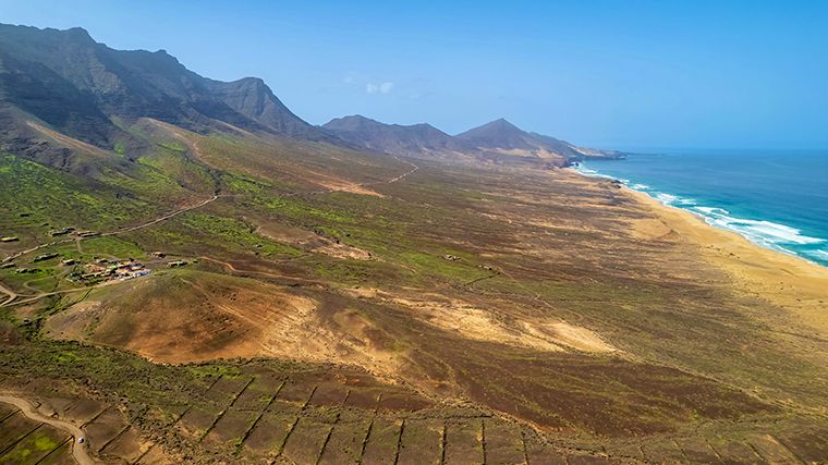
Cofete Beach is perhaps the most visually stunning beach on Fuerteventura. The surf and rip currents make it too dangerous to swim in the ocean, but there’s nothing wrong with dipping your feet in the water to cool off a bit. The only question is: how do you get there, since there are only unpaved trails leading to it? We recommend leaving your rental car behind and, just this once, using public transportation. Line 111 runs through this area with special 4×4 vans.
Another way to enjoy the view (though not the beach itself) is the hike to the island’s highest peak, Pico de la Zarza. It’s a fairly challenging hike of over six kilometers, so only attempt it if you’re in excellent physical condition and have good hiking boots. At an elevation of 807 meters, you’ll be rewarded with a fantastic view! There’s a parking lot at the start of the trail. To get there, take the exit for Vinamar from the FV-2 in your rental car, then follow the sign for “campo de golf” and take the right-hand road uphill at the next fork.
Faro de La Entallada
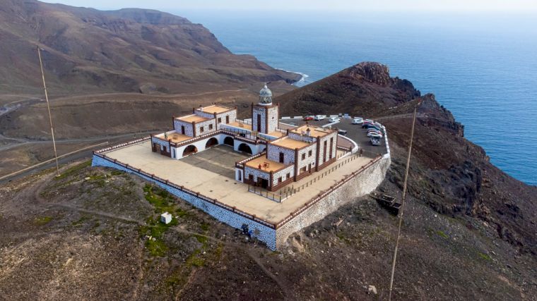
An easier-to-reach viewpoint is the La Entellada lighthouse, just east of the towns of Gran Tarajal and Las Playitas. In addition to offering a beautiful view of the Atlantic Ocean, this lighthouse is a fine example of Fuerteventura’s traditional architecture. For the last two kilometers, the road climbs to 200 meters above sea level. The road is quite narrow here, so drive carefully and look far ahead. Morocco lies just 100 kilometers to the east, making this the point in the entire Canary Islands archipelago closest to the African continent.
Take a rental car to the best surf beaches
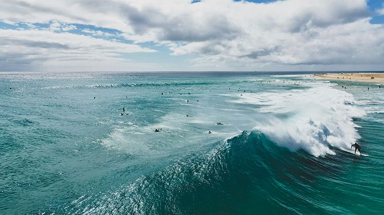
Fuerteventura is perfect for windsurfing and kitesurfing. In the summer, between April and September, it’s quite windy due to the northeasterly trade winds that blow constantly. There’s also wind the rest of the year, though it’s slightly less reliable. The north, around Corralejo, has a more consistent but lighter wind than the south of the island.
The Grandes Playas are located just south of Corralejo. The section known as Flag Beach is a favorite among local surfers. El Cotillo, and particularly Playa del Castillo, is also a well-known surfing spot. In the summer, this spot is great for beginners; in the winter, the waves are powerful, making it ideal for experienced surfers. Playa de Sotavento is a kilometer-long tidal lagoon, a perfectly sheltered spot for beginners. The annual World Windsurfing and Kitesurfing Championships are held here in July. The fishing village of Majanicho is situated in a bay along the north coast. The water in the bay itself is calm; the waves break on the underwater reefs on both sides of the bay. It’s a particularly popular surfing spot in the winter when the trade winds blow from the east and the water is forced through the strait between Lanzarote and Fuerteventura.
A local surfboard manufacturer has more detailed information about windsurfing locations on Fuerteventura.
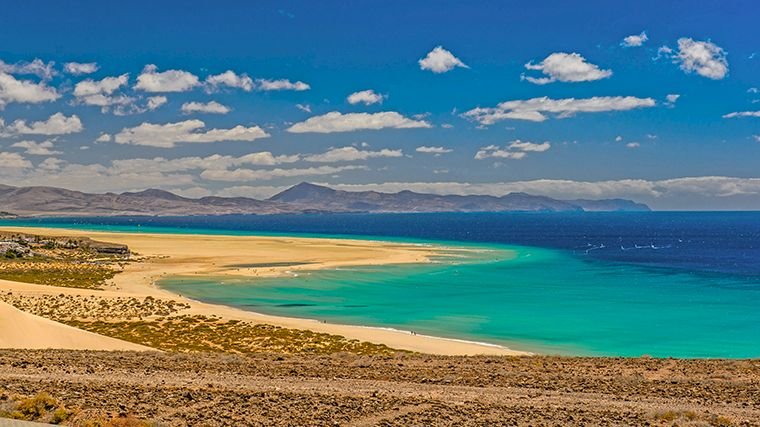
Best Dive Sites Near Fuerteventura
El Jablito Beach is an ideal diving spot for beginners. The shape of the land protects it from strong currents, allowing you to dive there year-round. You can reach this dive site, with a maximum depth of thirteen meters, directly from the beach.
The La Caleta dive site is accessible after a short boat ride from the pier at Caleta de Fuste. Here, too, there is little current. In addition to marine life, you can see several shipwrecks on the rocky seabed.
Bajón del Río is the strait between Corralejo and the islet of Lobos. From the golden seabed at a depth of eighteen meters, meter-high volcanic rocks rise up with umbrella-shaped tops. During your descent, you’ll be surprised by the explosion of marine life surrounding these gigantic “mushrooms.” With a little luck, you might even spot a stingray on the sandy bottom.
Off the coast of Ajuy on the island’s west coast, you’ll also find stunning volcanic rock formations, overhangs, and drop-offs. At this dive site, you can spot barracudas, horse mackerel, groupers, parrotfish, and Canarian lobsters. Suitable only for very experienced divers due to rough seas and strong currents.
Natural Pools in Fuerteventura
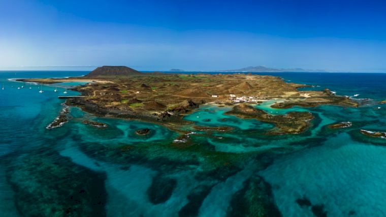
Fuerteventura’s idyllic beaches are the island’s main attraction, but when there are certain currents or strong winds, the waves can get very high. That’s great for surfers, but less enjoyable if you just want to take a dip. That’s where the natural pools come in handy. Fuerteventura has several of them, the best known being Aquas Verdes, northwest of Betancuria. There are several pools, one of which is quite large and deep. The shapes and colors of the surrounding rocks are stunning. There’s also a beautiful natural pool near the tourist resort of Caleta de Fuste, but it’s much more crowded. You’ll have to scramble over the rocks to see it from above. The green-colored rocks underwater are a magnificent sight, though they can be slippery. And then there are also beautiful natural pools near the uninhabited islet of Lobos, which you can reach from Corralejo by ferry or water taxi.
Most natural pools are only visible at low tide. But how do you know when low tide is? You can easily check the website seatemperatu.re, which lists the tides alongside the sea temperature for various locations.
Rental Car and Unpaved Roads on Fuerteventura
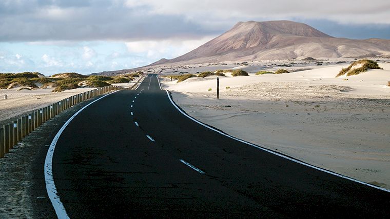
The main roads on Fuerteventura are paved and very well maintained, but there are also quite a few unpaved roads on the island that lead to hidden beaches. Sometimes the beginning of such a road seems perfectly drivable. As tempting as it may be, we advise against driving on these roads in a rental car. All car rental companies on Fuerteventura prohibit driving on unpaved roads. If you do so anyway and your car is damaged or you get stuck, you’ll be fully responsible for the costs of repairs and/or towing. Even if you have insurance with comprehensive coverage! Only if you’ve rented a 4×4 off-road vehicle may you be permitted to drive on these roads, but be sure to check this thoroughly with the rental company and have it specified in the contract.
Island Hopping to Other Canary Islands
When visiting the Canary Islands, you don’t have to limit yourself to just one island. It’s not recommended to take your rental car on a ferry, as this is not only quite expensive but is usually not permitted by the rental company. However, you can easily rent a car on different islands separately through our website. The island closest to Fuerteventura is Lanzarote. The ferry makes the half-hour crossing from Corralejo to Playa Blanca. Rent a car to discover Lanzarote’s unique sights. The port of Morro Jable is the departure point for ferries to Gran Canaria and Tenerife. The northern parts of those two islands, in particular, are much greener than Fuerteventura. Read more about them in our blogs “Exploring Gran Canaria with a Rental Car ” and “12 Must-See Stops in Tenerife.” Go island hopping and discover just how diverse the Canary Islands are!

Where would you like to rent a car?
- 24000+ pick-up locations
- Free cancellation
- Independent comparator

Useful tips for a well-prepared trip
Which insurance should I choose, and what's the deal with the deposit? Read our articles with useful information and tips to ensure you choose the right rental car for you.